Where the Five Temples Actually Sit on the Map
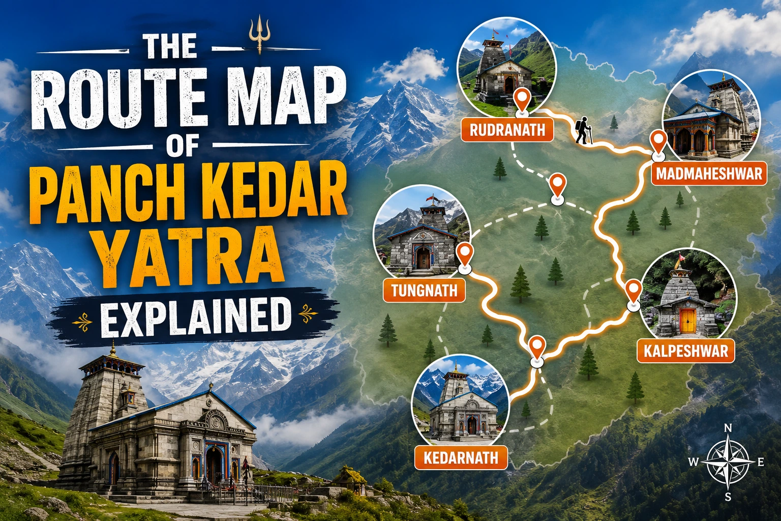
Most people come to Panch Kedar knowing the names — Kedarnath, Tungnath, Rudranath, Madmaheshwar, Kalpeshwar — long before they understand how those five points sit on the ground. That’s the gap this guide fills. Not cost, not itinerary, not difficulty — just the geography: where each temple is, what village you pass through to get there, and how the five are actually linked across Rudraprayag and Chamoli districts.
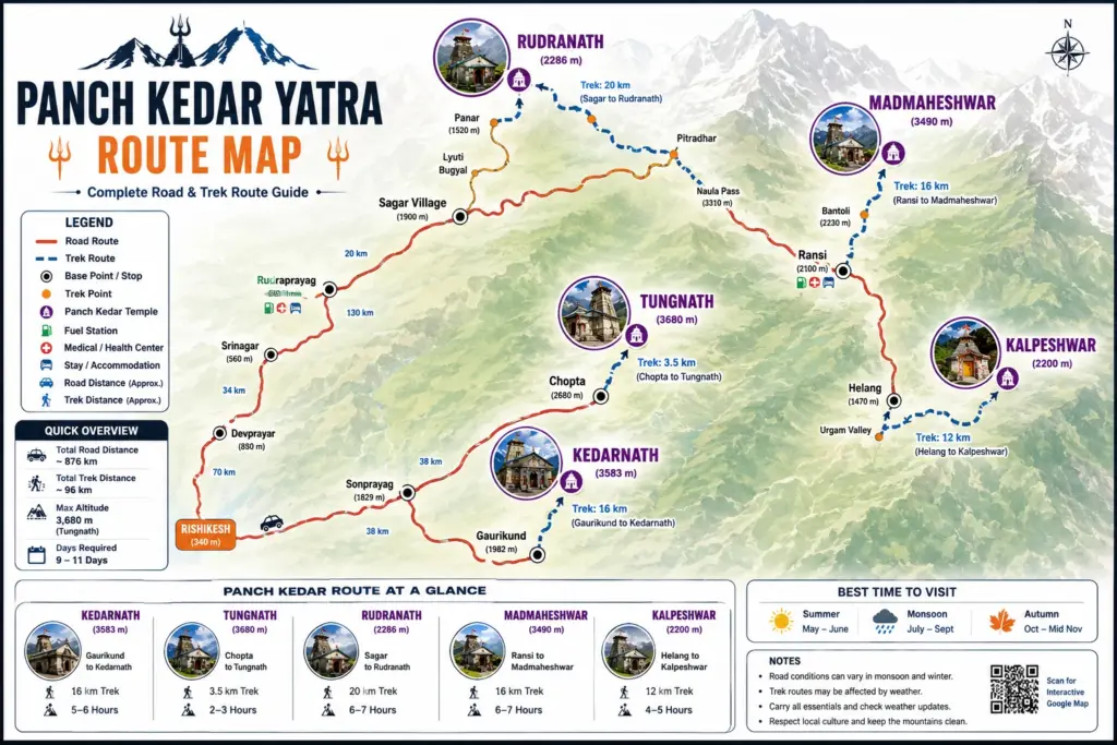
We say “linked” deliberately rather than “connected by a single trail,” because that’s the most common misunderstanding. Panch Kedar isn’t one continuous footpath from temple to temple. It’s five separate approach routes, each starting from a different roadhead, stitched together by road transfers in between. Knowing which parts are trek and which are drive changes how you read every itinerary you’ll come across later.
| Total Span | Temples Covered | Route Type | States/Districts |
| ~170 km, Kedarnath to Kalpeshwar | 5 (Kedarnath, Tungnath, Rudranath, Madmaheshwar, Kalpeshwar) | Linked but non-contiguous — road + trek segments | Rudraprayag & Chamoli, Uttarakhand |
The Order Most Yatris Follow, and Why
Tradition sequences the five temples by the part of Shiva’s body each represents — hump, arms, face, navel, hair — but almost no operator treks in that exact order today, because it isn’t the most efficient way to move through the terrain. Most groups instead follow the geography: starting from Kedarnath in the south, moving north through the Madmaheshwar and Tungnath corridor, then across to Rudranath, and finishing at Kalpeshwar near Helang. We’ll walk it in that practical order.
Leg by Leg: How the Route Actually Unfolds
Here’s the village-to-village skeleton of the yatra. Road stretches and trek stretches are called out separately, because they’re not the same kind of day.
| Leg | From → To | What You’re Actually Covering |
| 1 | Sonprayag → Gaurikund → Kedarnath | Road ends at Sonprayag; Gaurikund is the last motorable point. From there it’s a 16 km trekking climb along the Mandakini valley to Kedarnath. |
| 2 | Ukhimath → Ransi → Gaundhar | A road transfer takes you from the Kedarnath region to Ukhimath, then on to Ransi village — the trailhead for Madmaheshwar. Gaundhar is the last village before the trek climbs into forest. |
| 3 | Gaundhar → Budha Madmaheshwar → Madmaheshwar | The trek follows the Madhyamaheshwar Ganga upstream through forest and meadow, passing the older Budha Madmaheshwar shrine before reaching the main temple. |
| 4 | Ukhimath → Chopta → Tungnath | Back on the road briefly, then a short, well-graded climb from Chopta — the shortest and most walked leg of the entire yatra. |
| 5 | Gopeshwar → Sagar Village → Rudranath | A road transfer to Gopeshwar and on to Sagar, then a demanding climb through oak and rhododendron forest, past Panar and Lyuti Bugyal, to Rudranath. |
| 6 | Helang → Urgam Valley → Kalpeshwar | The final leg drops in elevation. From Helang on the Badrinath highway, a short walk through the Urgam Valley reaches Kalpeshwar — the only Panch Kedar temple open all year. |
What the Map Doesn’t Show: Road vs Trek Reality
On paper, the distance between temples looks continuous. On the ground, it isn’t. Roughly half of the total Panch Kedar route is covered by vehicle — Ukhimath, Chopta, Gopeshwar, and Helang all function as road hubs that connect one trekking leg to the next. If you’re mapping this yourself, the mistake to avoid is assuming you can walk from one temple’s trailhead directly to the next; you can’t, and every group itinerary you’ll see is really built around these four road hubs.
You might be interested in these treks
Roopkund Trek
₹15,500
Hampta Pass Trek
₹7,500
Ranthan Kharak Trek
₹9,500
Kagbhusandi Lake Trek
₹29,500
Bhrigu Lake Trek
₹8,599
| Reading the Route Like a Local • Ukhimath is the hinge point — most yatris pass through it twice, once heading to Madmaheshwar and again heading toward Tungnath. • Gopeshwar, not Sagar, is where the road ends for Rudranath — Sagar is a further short drive or walk beyond it. • Kalpeshwar is the only temple reachable without a multi-day trek, which is why it’s usually saved for last or done as a short standalone visit. • Rivers to note along the way: the Mandakini (Kedarnath leg), the Madhyamaheshwar Ganga (Madmaheshwar leg), and the Alaknanda, which the route brushes near Helang. |
Alternate Routings Operators Use
Not every operator sequences the yatra the same way, and it’s worth knowing why. Some groups start from Kalpeshwar and work backward toward Kedarnath, which shortens the final stretch when energy is lowest. Others combine the Madmaheshwar and Tungnath legs into a single loop out of Ukhimath before continuing on to Rudranath, since both trailheads share that same road hub. Neither approach changes the geography — it just changes which hub you treat as your base for the middle stretch of the yatra.
Frequently Asked Questions
Is the Panch Kedar route one continuous trekking trail?
No. It’s five separate trekking approaches connected by road transfers through hub towns like Ukhimath, Chopta, Gopeshwar, and Helang.
Which temple is furthest from the others on the map?
You might be interested in these yatras

Kedarnath sits furthest south along the Mandakini valley, while Kalpeshwar in the Urgam Valley near Helang is the furthest north — the two effectively bookend the route.
Do all five temples fall in the same district?
No. Kedarnath and Madmaheshwar fall within Rudraprayag district, while Tungnath, Rudranath, and Kalpeshwar fall within Chamoli district.
Which road hub connects the most legs of the route?
Ukhimath. It sits between the Kedarnath region, the Madmaheshwar trailhead at Ransi, and the Tungnath trailhead at Chopta, making it the busiest transit point on the yatra.
Can the route be mapped and walked independently, without a guide?
The trekking legs themselves are walkable independently, but coordinating the road transfers between five separate trailheads across two districts is where most self-planned trips lose time. This is exactly the logistics FirstTrek’s Panch Kedar teams handle for you.
Plan the Route With Us
Understanding how the five temples connect is the first step. Turning that into a workable itinerary — with the right road transfers, the right trailhead timing, and the right rest days built in — is where FirstTrek’s Panch Kedar Trek packages take over. Explore the full Panch Kedar Trek page for dates and packages, check the day-wise itinerary for how we sequence these six legs on the ground, and see the cost breakdown for what’s included at each stage.